E-Flora BC: Electronic Atlas of the Flora of British Columbia

Phalaris arundinacea L. var. arundinacea
reed canarygrass
Poaceae (Grass family)

Introduction to Vascular Plants
Once images have been obtained, photographs of this species will be displayed in this window.Click on the image to enter our photo gallery.
Currently no image is available for this taxon.
E-Flora BC Static Map
Distribution of Phalaris arundinacea var. arundinacea
Click here to view our interactive map and legend
Details about map content are available here
Click on the map dots to view record details.

Species Information

Click on the image below to view an expanded illustration for this species.


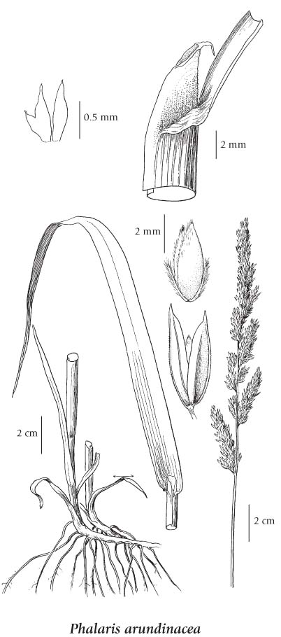
General:
Perennial grass from conspicuous rhizomes; stems 50-150 (200) cm tall.
Leaves:
Sheaths open; blades flat, 7-17 mm wide; ligules rounded, usually with irregular, jagged margins, turned backwards, short-hairy externally, 4-10 mm long.
Flowers:
Inflorescence a compact panicle, 7-15 (25) cm long, the branches more or less spreading at maturity; glumes slightly unequal, minutely rough and short-hairy, 3-nerved, sharp-pointed, 4.5-5 mm long; sterile lemmas hairy, brownish, 1-1.5 mm long; fertile lemmas nearly smooth, lightly 5-nerved, 3-4 mm long; paleas 2-nerved, nearly equal to the lemmas; lodicules lanceolate, about 0.5 mm long; anthers 2.5-3 mm long.
Notes:
Sometimes introduced as a pasture grass. The variegated ornamental form (forma variegata [Parnell] Druce [var. picta L.]) sometimes occurs as a garden escape.

Source: The Illustrated Flora of British Columbia

Habitat / Range

Wet meadows, ditches and lakeshores in the lowland and steppe to subalpine zones; common in S BC, rare northward; circumpolar N to AK, YT and NT, E to NF and S to ME, MA, PA, VA, AL, AR, OK, NM, AZ and CA; Eurasia.

Source: The Illustrated Flora of British Columbia

Ecology

Ecological Framework for Phalaris arundinacea var. arundinacea

The table below shows the species-specific information calculated from
original data (BEC database) provided by the BC Ministry of Forests and Range.
(Updated August, 2013)

Site Information
Value / Class

Minimum

Average

Maximum

Elevation (metres) 5 597 1642
Slope Gradient (%) 0 1 50
Aspect (degrees)
[0 - N; 90 - E; 180 - S; 270 - W]
12 55 360
Soil Moisture Regime (SMR)
[0 - very xeric; 4 - mesic;
8 - hydric]
0 5 8
Modal Nutrient Regime
Class
D
Number of field plots
 species was recorded in:
116
Modal BEC Zone Class
IDF
All BEC Zones (# of stations/zone) species was recorded in: BG(14), CDF(10), CWH(16), ESSF(1), ICH(11), IDF(36), MS(2), PP(6), SBPS(2), SBS(15)

Taxonomic and Nomenclatural Links

Additional Photo Sources

General References